Regulatory Compliance & Permitting
Services
FEMA
Environmental Planning
Storm Water Pollution Prevention and Maintenance Plans
The most common services that we offer are plot plans for additions, lot staking and new construction support for building permits of single, multi-family and commercial projects. Depending on whether you’re a homeowner, business owner, or contractor, your needs for a land survey will vary. Here are a few of the most common services for you:
Home Owners: Lot staking, plot plans for addition, septic system designs and elevation certificates
Businesses: Lot staking, plot plan for expansion or sign permit.
Contractors: Construction support and project management with local agencies
Noonan & McDowell also specializes in:
Determination of wetland resources.
Elevation Certificates: Insurance rating certificate for those who need flood insurance.
Soil & Water Evaluation
Determination of soil profile, seasonal high water table and constant head infiltration testing.
Compliance Support
Site inspection and reporting for permitting compliance.
Litigation Support: Expert witness for land surveying and civil engineering concerns.
Site Assessment
Review of property development potential with current local, state and federal restrictions.
Land Surveys
Land court, topographic, title insurance, court exhibits, condominium plans, lot staking and plot plans.
LOMA and eLOMA
Filings to have a parcel or structure removed from an area designated by FEMA has a flood hazard area.
Types of Surveys
Land Surveying can be performed for a number of purposes. Single family residential is usually for installation of fences, yard improvements or an addition to the existing dwelling. Commercial is typically for new construction or expansion of an existing facility.
Plot Plans
If you are planning an addition you will need an accurate location of the existing structures to determine were and how large an addition you can construct.
Topographic Plans
Architects, Landscape Architects and Engineers as tools in their design use topographic plans.
Land Court Plans
Land Court surveys are performed for various reasons, including ownership claims (for land that you do not own, but are using without challenge or notice by the owner), and to clear ownership in land that you have a color of title for. The Land Court can also serve as a place to resolve boundary disputes.
Condominium Plans
These plans provide for the conveyance of multiple units (residential or commercial) within a single or group of structures. There are two separate plans that are needed to describe the condominium. The first is the Site Plan. This identifies the location of the units and the dimension of the building and adjacent exclusive use areas for each unit. It also identifies the common areas and physical improvements on the property. The other plan is the Unit Plan. The unit plan gives the interior dimensions and area of the unit. A condominium is best described as owning a cubic of air space. The Unit Plan describes the shape of the space and the Site Plan identifies were that space is within the parcel.
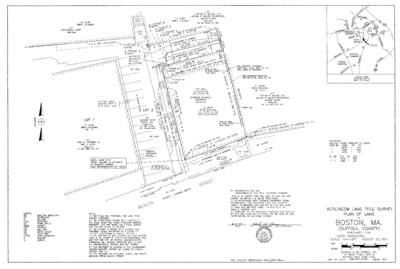
Title Insurance Plans
These plans are prepared for title insurance companies for the purpose of insuring title to property. It identifies any easement of record, which may benefit or encumber the property. It also shows encroachments by others or by the owner of the property. The title Insurance plan is prepared in accordance with the standards established by: American Land Title Association and The American Congress on Surveying and Mapping.
FEMA
If you are located within an area of 100 year flooding you are required by you lender to obtain Flood Insurance. Noonan & McDowell, Inc. can prepare an Elevation Certificate, which is used by your insurance company to establish the cost of the flood insurance. If we find that your structure is above the 100-year flood level, we can file a LOMA or eLOMA to have you removed from the requirement of obtaining the flood insurance.